| � Previous :: Next � |
|
| Re: Proposed Changes - Overland MapThursday, October 4th, 2007 at 3:16 pm
Working Example
A working example of the code has been set up and connected to the Highport Municipal Clinic and the Highport Market Square. There is a hidden exit called "magical valley". It's currently a square valley surrounded by mountains.
Here's a quick cap: (15 H 3 M): w
Highport Municipal Clinic
You are in the Highport Municipal clinic.
Here is where you may get healing assistance as well as rest if
you feel fatigued. The doctors and surgeons can help you if you
are hurt, diseased, or even blind and deaf! Of course, they will
require a fee from you unless it is the most minute of
injuries you have. Also, as is true in any clinic, the wait is
always quite excruciating.
Obvious exits: east.
You see Dominus the Dungeonmaster, Fubar(afk).
You see three doctors.
You see a Clinic Staff Sign, a piece of Slayyer's shit, some pixie dust.
(15 H 3 M): go magic
The World of Derlith
.-----------.
|fggggfghggf|
|gfggggfghgg|
|ggfggggfghg|
|gggfggggfgh|
|ggggfggggfg|
|fgggg@ggggf|
|gfggggfgggg|
|hgfggggfggg|
|ghgfggggfgg|
|gghgfggggfg|
|fgghgfggggf|
.-----------.
Obvious exits: north, east, south, west, northeast, northwest, southeast, southwest, highport.
(15 H 3 M): If you go far enough east: (15 H 3 M): e
The World of Derlith
.-----------.
|hggfggmmmmm|
|ghggfgmmmmm|
|fghggfmmmmm|
|gfghggmmmmm|
|ggfghgmmmmm|
|gggfg@mmmmm|
|ggggfgmmmmm|
|fggggfmmmmm|
|gfggggmmmmm|
|ggfgggmmmmm|
|gggfggmmmmm|
.-----------.
Obvious exits: north, east, south, west, northeast, northwest, southeast, southwest.
(15 H 3 M): e
You can't go there!
(15 H 3 M): you are the @ symbol in the middle of the map. g stands for grassland, f for forest, h for hill and m for mountain. Also, 2 east of the clinic entrance (there is a big H on the map) is a hidden exit leading to the square.
Thoughts / Opinions?
This is what I've envisioned the overland map to be like. Go the valley, move around and see how it works. I want your opinions on it. Does it suck? Should we abandon this project? Do you think it's totally awesome? If you don't like how the system works, or you have improvements to suggest, now is the time to speak up.
Zerk brought up the question of hidden exits - are players going to have to now search 100 rooms to find a special hidden exit? Won't that make finding things impossible? This is going to be a matter of building policy - we're not going to put hidden exits in obscure areas. If we do, there will be directions - "10 north and 17 east from Highport, search for a hidden tunnel!"
Another subject I just thought up - having a map like this will greatly increase the usefulness of clairvoyance and track during pkill settings, especially if the target has the entire map to hide in. Thoughts on this?
Another point: vision is currently 5/5 in every direction, which looks pretty distorted. The original post had width being longer, which I'll put in to make it look less... blocky.
Post!
Also Bane: don't *t in to, out of, or around the valley yet. It crashes.  Heaven doesn't want me and Hell is afraid I'll take over.  |
|
| Re: Proposed Changes - Overland MapFriday, October 5th, 2007 at 4:16 pm
Awesome idea in my opinion. I hate slowly working my way from town to town. It would take some getting used to but I think it is important to keep the mud changing. Besides, it would give some of the veteran players something new to master
|
|
| Re: Proposed Changes - Overland MapFriday, October 5th, 2007 at 9:14 pm
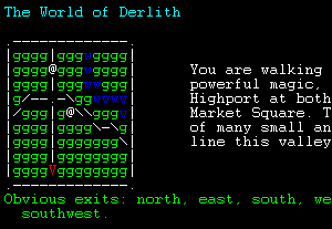
Here's an update to the map interface - doesn't look so stretched. It also demonstrates the text that accompanies it - this text will give you info about the area you're in.
The World of Derlith

.-------------.
|mmmmmmmmmmmmm|
|ghggfggghmmmm|      You are walking in a magical valley. Through some
|fghggfgggmmmm|      powerful magic, it is connect to the city of
|gfghggfggmmmm|      Highport at both the Municipal Clinic and the
|ggfghg@fgmmmm|      Market Square. This luxurious valley is the home
|gggfghggfmmmm|      of many small animals and birds. Great mountains
|ggggfghggmmmm|      line this valley on all sides.
|fggggfghgmmmm|
|ghggggfghmmmm|
.-------------.
Obvious exits: north, east, south, west, northeast, northwest, southeast, southwest.

:
Heaven doesn't want me and Hell is afraid I'll take over.  |
|
| Re: Proposed Changes - Overland MapFriday, October 12th, 2007 at 1:42 pm
Anybody know any good map editors out there?
This one contain the functionality I'm looking for, but it crashed on a moderately sized map. I'm looking for something to edit the Realms map, and I'd really prefer not to have to write my own software.  Heaven doesn't want me and Hell is afraid I'll take over.  |
|
| Re: Proposed Changes - Overland MapSunday, October 14th, 2007 at 12:20 am
is it me or did the exit for gnome dissapear?
|
|
| Re: Proposed Changes - Overland MapTuesday, October 16th, 2007 at 12:32 pm
The Gnomebarrow exit was removed, it was just an example of how the map would work.
In fact, the whole magical valley has been removed because I'm getting close to getting a REAL map up. I've converted the Realms map into a format the mud can understand, and right now I'm testing some point-in-polygon code. Essentially, given some polygon, the code tells if you are inside or outside the polygon. We can use polygons to keep track of lots of stuff - kingdom borders, wandering-monster areas, zones (a Hellbog zone, for example).
Here's a screencap of what part of the map looks like. It's only a prototype so far:

After this polygon code is done, I'll start with line-of-sight.  Heaven doesn't want me and Hell is afraid I'll take over.  |
|
| Re: Proposed Changes - Overland MapWednesday, October 17th, 2007 at 9:20 pm
Another quick update: you can now see other people on the map. They show up as @s, just like you do.
  Heaven doesn't want me and Hell is afraid I'll take over.  |
|
| Re: Proposed Changes - Overland MapThursday, October 25th, 2007 at 4:23 pm
Line of Sight
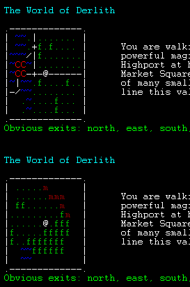
Line of sight has been coded. Essentially, this means that you cannot see as far as the eye can see - especially if mountains are in the way. Here are two examples of line of sight in action (including some map updates):

Note that flying will greatly increase your vision through (well, over) some terrain. Mountains, for example, will now be difficult to see over, not impossible.
Also: I threw in an option to invert area colors using the set command. This is usefully really only for me. The colors you see in the image above should be the ones you see on the map.  Heaven doesn't want me and Hell is afraid I'll take over.  |
|
| Re: Proposed Changes - Overland MapTuesday, October 30th, 2007 at 12:33 pm
Zones
The code for defining zones is now done. It took some time because of bugs with code I borrowed - I wasn't familiar with it and it took me longer to figure them out.
Currently, on the test port, the borders of the three main kingdoms of been defined (Sendral, Caladon, and Highport). There are a couple more things to code for zones: auto-enter, terrain/map specific zones, and wandering monsters within zones, but this is the last major piece of code that needed finishing before the overland map can go live.
Of course, once all the code is done, I'll need to take the time to convert everything properly. I'm hoping that this will all be finished within a few weeks.  Heaven doesn't want me and Hell is afraid I'll take over.  |
|
| Re: Proposed Changes - Overland MapWednesday, October 31st, 2007 at 1:54 am
Thanks for all the cool stuff you are coding. Save time and carpal tunnel.
|
|
 Announcements
 In-Game Discussion
 Non-Game Discussion
 Text Caps & Stories
 Flame!
 Questions
 Igmoo's Ethereal Tradepost
 Tips and Strategies

 Heaven doesn't want me and Hell is afraid I'll take over.


